Islands of the Caribbean

There are many islands in the Caribbean with significant human population.  There are thousands of small islands and key or cays, many uninhabited.  The state of Florida contains the Florida Keys and the Dry Tortugas that lie about 67 miles west of Key West.  The Dry Tortugas are a small group of islands designated as a National Park and inhabited only by a group of about 15 National Park employees.
The Florida Keys consists of 1700 small islands, most of which are not inhabited. 800 of these keys are mapped and about 30 are inhabited. Whereas most of the Caribbean Islands are volcanic in origin, the Florida Keys are exposed portions of an ancient coral reef. Most keys are only accessible by boat such as those in Biscayne National Park. The inhabited islands are accessible via an overseas highway extending as a series of bridges from the Florida mainland south of Miami.
 
The Florida Keys (from the Spanish word Cayo, meaning small island) were first charted in 1513 by Juan Ponce de Leon. Until the completion of an overseas railway in 1910, the islands were only accessible by water. The Spanish had settlements on the keys, but United States settlers did not start appearing until the 1800’s. During the American Civil War, the Florida Keys were part of the Confederacy.
 
The following is a list of the inhabited islands in the Keys, starting with those in Miami-Dade County and ending at Key West in Monroe County: These are islands that have residences. Although inhabited, some of these keys are private owned and restricted to residents only. Some keys, although accessible, are not included because they have businesses such as fast food and service stations or provide road access to other keys, but have no permanent residents.
 
Florida Keys  
  • Key Largo was settled sometime before 1870 when a Post Office was built on the island.
  • Plantation Key
  • Windley Key (Part of the Village of Islamorada)
  • Tea Table Key (Part of the Village of Islamorada)
  • Upper Matecumbe Key (Part of the Village of Islamorada)
  • Lower Matecumbe Key (Part of the Village of Islamorada)
  • Islamorada Key
  • Craig Key
  • Fiesta Key
  • Long Key (the city of Layton is located on Long Key)
  • Conch Key
  • Duck Key
  • Knights Key (Part of the City of Marathon)
  • Grassy Key (Part of the City of Marathon)
  • Key Vaca (Part of the City of Marathon)
  • City of Marathon consists of a number of small keys, some uninhabited
  • No Name Key
  • Big Pine Key
  • Little Torch Key
  • Ramrod Key
  • Summerland Key
  • Sugerloaf Key
  • Saddlebunch Keys. These are a series of mangrove islands. Bay Point and Bluewater Key are the only inhabited islands in the Saddlebunch Keys.
  • Shark Key
  • Geiger Key
  • Big Coppitt Key
  • Boca Chica Key
  • Raccoon Key contains the community of Key Haven
  • Stock Island (a portion of the Island is part of the City of Key West)
  • Fleming Key (Part of the City of Key West but also part of the Key West Naval Air Station and only accessible to military personnel)
  • Dredgers Key (Sigsbee Park) is part of the Key West Naval Air Station and has a population of military and civilian employee families. It is an artifical key created from material dredged to make seaplane runways in the shallow bay.
  • Sunset Key (Part of the City of Key West)
  • Key West was originally known as Cayo Hueso, which means Bone Island. Even though the British took control of Key West in 1763, it was not permanently settled. After the American Revolution it reverted to Spanish control . In 1822, Matthew Perry claimed Key West for the United States. Permanent settlement took place beginning in 1829. Most of the settlers were from the Bahamas. These were the children of British Loyalists who fled from the United States after 1776. Their descendants still live there in an area of the island known as Bahama Village in Old Town.
Bermuda  is not within the Caribbean, nor with any other area of this publication.  For research purposes, I have included in this chapter.  Bermuda is located in the Atlantic Ocean off the eastern coast of the U.S., 640 miles east-southeast of Cape Hatteras, North Carolina. It is now part of the British Overseas Territory.

Islands of the Caribbean

Most of the Caribbean Islands were formed by volcanic activity. They lie in a region of intense seismic activity, which includes frequent earthquakes and volcanic eruptions.
 
European contact began with the voyages of Christopher Columbus who first landed in the Bahamas in 1492. The Portuguese and Spanish began claiming territories. Gold, sugar cane, rum and other riches available in this area made it an area of European conquest, war, and exploitation for centuries. England, France and the Netherlands also established colonies to gain economic advantage. The Spanish in particular enslaved the native population nearly to the point of extinction. All of the European nations imported slaves from Africa to work the plantations in their colonies. Since there are thousands of islands, most are either uninhabited or have been settled recently. The presence of fresh water has always been a deciding factor, and with today’s power boats available to bring water in on demand many small islands have private ownership or are used as research stations and lighthouses.
 
The following lists inhabited islands of the Caribbean, showing what countries colonized them. Dates are provided, along with changes in ownership, treaties, independence and current status to help Family Historians with ancestry in this area.
The Bahamas are in the British Overseas Territory and consist of more than 3000 islands, cays, and islets in the Atlantic Ocean South of Florida.
The Commonwealth of the Bahamas consists of more than 3,000 Islands, cays and islets in the Atlantic Ocean Southeast of Florida.  The Bahamas were originally a British Colony, but became independent in 1963.  They are now part of the British Overseas Territory in the Commonwealth of Great Britain.  The Bahamas were settled in 1718.
 
Bahamas   
 Acklins Island
 Bimini Islands
 Cat Island
 Crooked Island
 Eleuthera Island
 Exuma
 Grand Bahama
 Abaco Island – Big & Little
 Great Inagua
 Long Island
 Man-O-War Cay
 Mayaguana
 New Providence
 North Andros Island
 San Salvador
 South Andros Island
Turks and Caicos.    Turks and Caicos. I have included East Caicos. It once had a population but has been uninhabited since the early 1900’s. 
These islands are part of the British Overseas Territory and are located at the southern end of the Bahamas Archipelago.
There are four divisions of the archipelago – East, Middle and North Caicos and the Providenciales all acquired by the British in 1783.
 

Central American Caribbean

Belize
Mexico
Panama
Honduras
Nicaragua
Corn Islands (Nicaragua)
The Corn Islands were leased by the U.S. from England in 1914 and a Coast Guard presence is maintained there to control drug traffic. Panama controlled islands are all in the Bocas del Toro Archipelogo and those of Honduras are in Honduras Bay.
Ambergris Caye
1848
British
Belize
Corn Islands
1655
British (1971 turned over to Nicaragua)
Nicaragua
Cozumel
17th Century
Spanish
Mexico
Isla Mujeres
17th Century
Spanish
Mexico
Bastimentos Island
16th Century
Spanish
Panama
Colón Island
16th Century
Spanish
Panama
Popa Island
16th Century
Spanish
Panama
Solarte Island
16th Century
Spanish
Panama
Guanaja
16th Century
Spanish
Honduras
Roatan
16th Century
Spanish
Honduras
Útila
16th Century
Spanish
Honduras

South American Caribbean

Venezuela
Columbia
South American Caribbean. Providencia was claimed by Spain, Argentina, Nicaragua and Columbia at various times.
Coche Island
1800’s
Spanish
Venezuela
Isla Margarita
1498-1914
Spanish
Venezuela
Providencia
1630
British (1803-1912) Columbia since 1912
Columbia
San Andrés
1627
British (Spanish since 1792)
Colombia
Greater Antilles.  The Greater Antilles contains three of the four largest islands in the Caribbean – Cuba, Hispaniola and Puerto Rico.  Hispaniola Island contains two nations, Haiti and the Dominican Republic.  Hispaniola was settled by the Christopher Columbus and La Isabela was founded in 1493 in present-day Dominican Republic as the first European settlement in the Americas.  From West to East, the Islands are Cuba, Hispaniola, and Puerto Rico. Jamaica in 90 miles south of Cuba and the Cayman Islands are northwest of Jamaica.
Haiti is part of island of Hispianola and contains following major islands all part of the Republic of Haiti. Independence from Spain was in the following indicated years.
Haiti                         1804 
Gonâve Island         1697 
Île à Vache Island    1697
Tortuga                    1697 
Dominican Republic is also a part of the island of Hispaniola in the Greater Antilles and became independent from Spain in 1821.
Jamica is part of the Greater Antilles, formerly known as Spanish Santiago founded by the Spanish in 1509, gained by the British in 1655 and became independent in 1962.
The Cayman Islands were originally Spanish and became part of the British Overseas Territory in 1661.  The major islands are Cayman Brac, Grand Cayman and Little Cayman.
Cuba was settled by the Spanish in 1511 and became Independent in 1902 as the Republic of Cuba.  It is the largest island in the Caribbean and has many smaller islands.
Cuba
1511
Spanish (1902 Independent)
Republic of Cuba
Cayo Coco
1511
Spanish
Republic of Cuba
Cayo Fragoso
1511
Spanish
Republic of Cuba
Cayo Guajaba
1511
Spanish
Republic of Cuba
Cayo Guillermo
1511
Spanish
Republic of Cuba
Cayo Largo del Sur
1511
Spanish
Republic of Cuba
Cayo Romano
1511
Spanish
Republic of Cuba
Cayo Sabinal
1511
Spanish
Republic of Cuba
Cayo Saetia
1511
Spanish
Republic of Cuba
Isla de la Juventud
1511
Spanish
Republic of Cuba
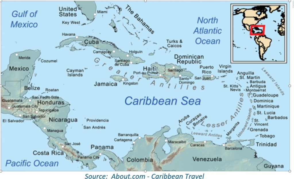
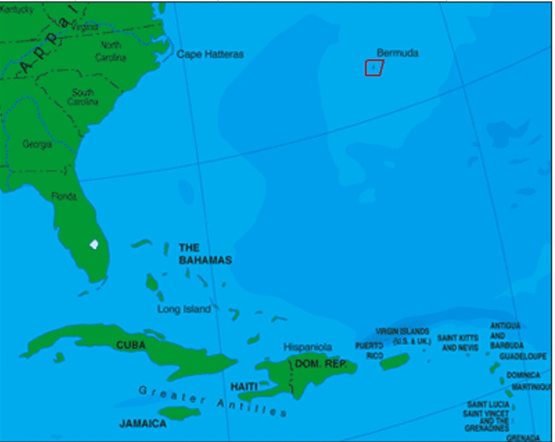
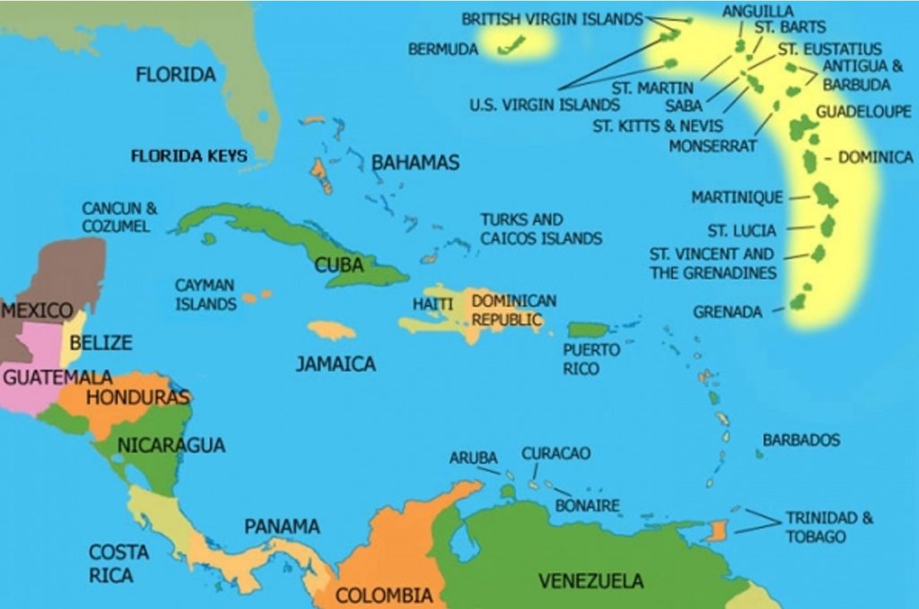
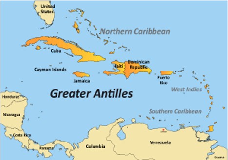
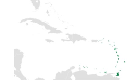
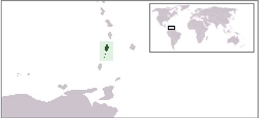
Lesser Antilles (also known as the Caribbees) are a long, partly volcanic island arc in the Caribbean Sea. Most of its islands form the eastern boundary of the Caribbean Sea with the Atlantic Ocean, with the remainder located in the southern Caribbean just north of South America.
 
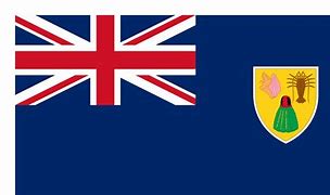
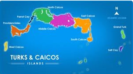
The Lesser Antilles and the Greater Antilles compose the Antilles, which are in turn part of the West Indies along with the Bahamas, the Cayman Islands, and the Turks and Caicos Islands.  The islands of the Lesser Antilles are divided into three groups. The Windward Islands in the south, the Leeward Islands in the north, and the Leeward Antilles in the west consisting of islands just off the coast of Venezuela.
The following compose the independent nations within the Lesser Antilles Leeward Islands
Antiqua and Barbuda
Barbados
Nevis
Saint Kitts

The following compose the French Overeseas Region (F.O.R.) of the Lesser Antilles Leeward Islands.

Saint Barthélemy
Guadeloupe (Official?)
Guadelope
Saint Martin
French Tricolor
Saint Barthélemy (Saint Barts)
1623
French (1946 F.O.R.)
Saint Martin
1648
French (2003 F.O.R.)
Guadeloupe-Grande-Terre
1635
French (1946 jF.O.R.)
Guadeloupe-Terre-de-Bas
1635
French (1946 F.O.R.)
Guadeloupe-Terre-de-Haut
1635
French (1946 F.O.R.)
Îles des Saintes
1649
French
La Désirade
18th Century
French
Marie Galante
1648
French
The following are the islands that are part of the Kingdom of the Netherlands in the Lesser Antilles Leeward Islands
Aruba
Bonaire
Curacao
Saba
Eustatius
Sint Maarten
Aruba
1508
Spanish (Dutch since 1836)
Bonaire
1621
Dutch
Curaçao
1600’s
Dutch
Saba
17th Century
Dutch
Sint Eustatius
1600’s
Dutch
Sint Maarten
1648
Dutch (2010 K.O.N.)

The following are the British Overseas Territory Lesser Antilles Leeward Islands

Anguilla
Montserrat
Anguilla
1650
British
Montserrat
1632
British
British Virgin Islands
 
Part of British Overseas Territory
Anegada
1672
British
Jost Van Dyke
1672
British
Tortola
1672
1648 Dutch – British since 1648
Virgin Gorda
1672
British
Puerto Rico
Puerto Rico is an island in the Lesser Antilles Leeward Islands. Puerto Rico and its islands are unincorporated territory of the United States.
Puerto Rico
17th Century
Dutch (1898 U.S. Protectorate)
Culebra
1880
Spanish (1917 Independent Municipality)
Isla Mona
15th Century
Spanish
Isleta de San Juan
15th Century
Spanish
Vieques
1811
Spanish
U.S. Virgin Islands
United States Virgin Islands
 
(1917 U.S,)
Saint Croix
1650
French (1713 British) (1917 U.S,)
Saint John
1718
Danish (1917 U.S,)
Saint Thomas
1672
Danish (1917 U.S,)
Water Island
1917
Danish (1917 U.S,)

The following are independent nations in the Lesser Antilles Windward Islands.

Dominica
Saint Lucia
Dominica
1673
British (1715 French) (1978 Independent)
Commonwealth of Dominica
Saint Lucia
1643
French (1814 British) (1979 Independent
Saint (Santa) Lucia
The Grenadines are windward islands, but they lie south of  the boundary of the Lesser Antilles.  This chain consists of two large islands, Saint Vincent to the north and Grenada to the south with a series of small islands between.  There are over 600 islands total, most of which are uninhabited.  The small islands are divided between ownership, part to Saint Vincent and part to Grenada.  Saint Vincent with its islands is the country of “Saint Vincent and the Grenadines”.  Grenada and its islands are the country of “Grenada”.
Grenada is an island country in the West Indies in the Caribbean Sea at the southern end of the Grenadines island chain. Grenada consists of the island of Grenada itself, two smaller islands, Carriacou and Petite Martinique, and several small islands which lie to the north of the main island and are a part of the Grenadines. It is located northwest of Trinidad and Tobago, northeast of Venezuela and southwest of Saint Vincent and the Grenadines. Grenada is also known as the “Island of Spice” due to its production of nutmeg and mace crops.[10]
Scroll to Top